 |
| This Berkeley map can be viewed online |
One in a series by CGS member Chris Pattillo, highlighting some of our holdings at the CGS Library in Oakland. For a fuller listing of books, journals, and more, consult the CGS Library catalog in WorldCat.
I began my research for this post by entering “maps” in the Library Catalog that is accessible from
I learned that there are 710 entries for maps available at our library plus 728 articles that contain something about maps. That’s not counting the many atlases in our collection. We have all sorts of maps including:
· City, county, state and country maps
· Traveler and tourist maps
· Highway and street maps
· Historical maps
· Ethnology maps
· Business and shopper maps
· Bicentennial maps
· Genealogical maps, and more
Each entry in the catalog includes a description that includes the name of the publication, a physical description, author, title, language, and something about the contents and subjects shown on the map. It also notes the staff view, OCLC number and identifies the genre of the item–in this case, maps. Scrolling down you find the cartographic mathematical data, i.e., the scale of the map and a few notes. The particular description I happened to open was for a map prepared for the Lowndes Bank, so in this case the notes tell us that the street names are indexed and there is an illustration of the bank.
 |
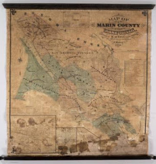
| Marin County, another map viewable online from our catalog |
The first listing is Map Guide to the U.S. Federal Censuses, 1790-1920. A description appears with the listing and explains that this map “shows U.S. county boundary maps for the census decades superimposed on modern county boundaries. Gives background information on each census, including census availability for each county…”
Some of the catalog listings include a button labeled “Access online.” Selecting this will take you to an image of the map. As an example, the link to the City of Berkeley map takes you to an 1880 Sanborn map of Berkeley which is part of the David Ramsey Map Collection. You can enlarge the map to study the detail and see for example that the campus was labeled “College Homestead” in 1880. Cataloging of the Ramsey collection was done by our very own volunteer Phil Hoehn.
The entry for Metsker’s map of Alameda County, California explains that this map shows “land grant lines, judicial townships, mines, roads, railroads, trails, creeks, rivers, schools, camps, airports, parks, lookouts, and power lines.
| Birds-eye view map of Reno, Nevada |
The Official Map of Alameda County, California, 1900links to the Earth Sciences & Map Library at UC Berkeley and divides the county into three sections. Each can be enlarged to study the detail.
I also found a Business Map of San Francisco, 1886that covers the blocks between Dupont and East Street from Market to Jackson Street. It identifies the business that occupied each parcel of every block in 1886. My great grandfather owned a surgical supplies business that was located on Kearney Street in 1889 so I looked for his business but did not find it. Another time I will look for a later map.
| Key system map for Oakland, Berkeley, Alameda and beyond |
You will find our physical maps in the flat file cabinet that sits to the right of the door to the classroom. The top few drawers contain large-format family trees. The maps are in the drawers labeled with numbers preceded by “G.” As I looked through the layers of maps a few caught my eye, including a colorful state map of Kentucky and Tennessee where my Stover ancestors are from; another Tennessee map dated 1795 that shows rivers and mountain ranges; a map of Texas Missions and Presidios dated 1760; a birds-eye-view map of Reno, Nevada; a map of San Francisco and the peninsula dated 1869 that depicts shockingly little development; a street map of Oakland from 1930; and a really interesting Key System map of Oakland, Berkeley and Alameda, showing the network of train routes including connections to small grids of streets that represented San Leandro, San Lorenzo and Hayward in 1911. Each of these maps provide a wealth of historic information and many are graphically interesting to study. I’m a bit of a map “junkie,” but I suspect just about anyone could find something of interest in the CGS map case.
| State map for Kentucky and Tennessee |
Phil Hoehn organized and cataloged our map collection as a member of the Library Committee. We are very lucky to have Phil as one of our many stellar volunteers. Phil is the co-author of Dictionary of Abbreviations and Acronyms in Geographic Information Systems, Cartography, and Remote Sensing, published while Phil worked at the UC Santa Barbara Map and Imagery Laboratory. Phil was also a regular contributor to the Western Association of Map Libraries News and Notes publication. Next time you see Phil be sure to say thank you for his ongoing service to our society!
 |
| Genie awards recipients. Phil Hoehn is on far right. |
Copyright © 2020 by California Genealogical Society
12
JAN
2020
JAN
2020
0
